
Some places on Earth look so surreal they seem like they belong in a dream — from shimmering salt flats to otherworldly rock formations and vibrant blue lakes. Whether you’re a travel photographer chasing iconic shots or a bucket‑list explorer hungry for unforgettable views, knowing where these magical places are makes planning your photo trip much easier. This guide showcases 23 places on Earth that do not feel real, complete with a map reference to help you plan the perfect photography adventure.
1) Salar de Uyuni, Bolivia
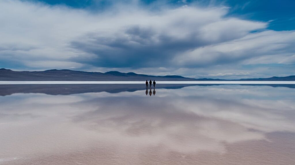
Map pin: Southwest Bolivia, Altiplano. When a thin sheet of water covers the salt, the ground turns into a sky mirror, and horizons look endless. Frame low to keep the reflection dominant, then place a person far away for scale. The “unreal” look comes from symmetry, so aim for centered compositions and clean lines. Cloud texture matters more than landmarks here, so plan around a day with layered cumulus.
For photo planning, capture two looks: the flooded mirror and the dry hexagon crust. A wide lens exaggerates the empty distance, while a longer lens compresses subjects into the reflection. Keep footprints out of your foreground by stepping to the side and shooting slightly ahead. Edit lightly: contrast in clouds, gentle clarity, and restrained saturation keeps the scene believable. (National Geographic)
2) Lençóis Maranhenses, Brazil
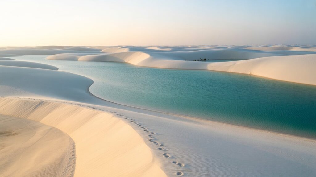
Map pin: Maranhão, northeastern Brazil. This landscape looks like a desert that forgot it’s supposed to be dry—white dunes filled with seasonal blue lagoons. The strongest photos come from height: shoot from a dune crest so the lagoon shapes read like abstract brushstrokes. Keep the horizon high or remove it entirely, so viewers focus on repeating curves and water pockets.
For photo planning, time your shoot for early or late light to carve shadow into the dunes. Walk the ridge lines, pause, then turn back and shoot your own footprints as leading lines before wind softens them. A polarizer can deepen sky contrast, but avoid making water too dark. If you include a person, place them on a dune edge to show scale without clutter. (Space)
3) Danakil Depression, Ethiopia
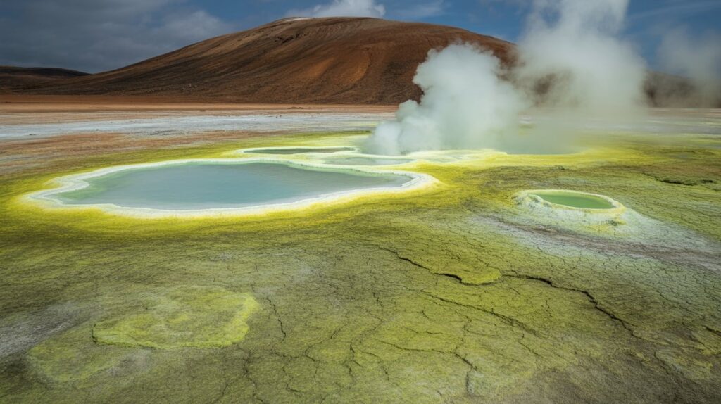
Map pin: Afar Region, Ethiopia. Danakil feels like a science-fiction set: vivid mineral colors, steaming vents, and sharp crust textures. Photograph it like a geology portrait—tight frames of patterns, then one wide shot that shows the scale. The “unreal” effect comes from color blocks, so keep compositions simple and let the ground do the work.
For photo planning, prioritize safety and heat management, then plan shots around texture and layers: foreground crust, mid-ground pools, background ridges. A mid-range zoom helps you isolate details without stepping into fragile areas. Harsh light is common here; use it intentionally by exposing for highlights so colors stay clean. In editing, avoid over-saturation; small boosts in contrast often look more natural. (Space)
4) Grand Prismatic Spring, Wyoming (Yellowstone)
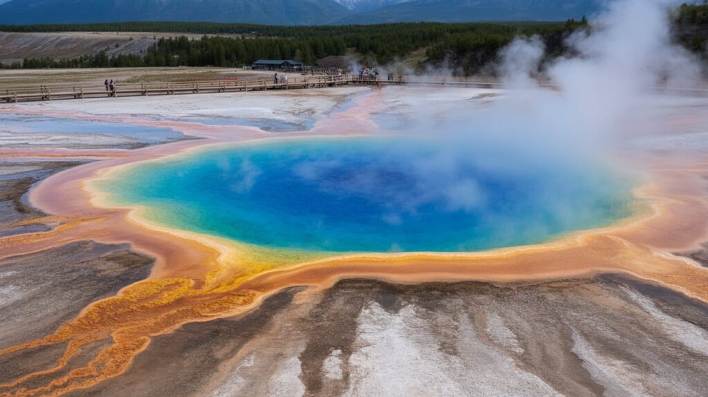
Map pin: Midway Geyser Basin, Yellowstone National Park. Grand Prismatic is famous for its color bands and huge scale, and it photographs best when you show the full “iris” shape. The easiest plan is two angles: the boardwalk level for steam and texture, and the higher overlook for the complete color rings. Steam becomes part of the composition, so embrace partial reveals.
For photo planning, arrive early to reduce crowds and to get calmer air for cleaner shapes. Expose carefully to protect the bright highlights in the rings, then recover shadows in post. A longer lens can compress steam layers for a dreamy look, while a wide lens tells the full story of size. Parking congestion is real at peak hours, so build buffer time into your shoot plan. (National Park Service)
5) Antelope Canyon, Arizona (Navajo Nation)
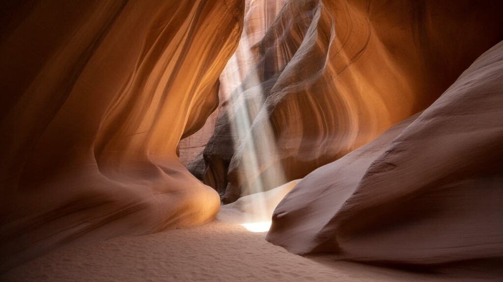
Map pin: Near Page, Arizona. Antelope Canyon looks unreal because the walls flow like fabric, and light turns sandstone into gradients. Plan for abstract compositions: shoot vertical frames that emphasize curves, then one wide shot that shows the slot’s depth. If you want light beams, prioritize the time window when sun angles can reach the canyon.
For photo planning, expect guided access and permit rules tied to Navajo Nation operations. Move fast but steady: dust, crowds, and low light can complicate sharp images. Use a higher shutter speed than you think, because people brushing past can shake the frame. Edit to preserve texture—clarity and gentle contrast help—while keeping the oranges realistic rather than neon. (Chron)
6) Giant’s Causeway, Northern Ireland
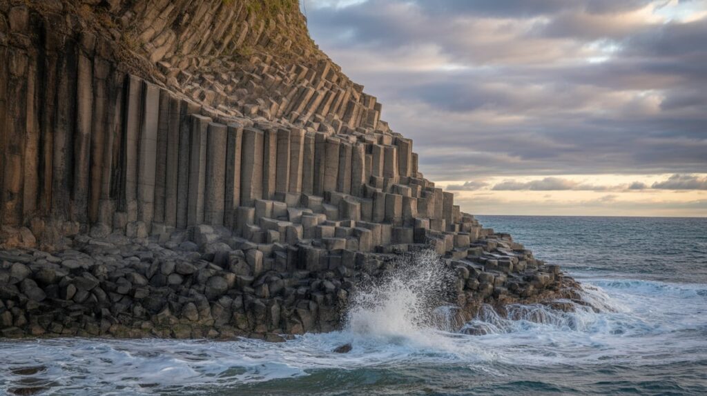
Map pin: County Antrim, Northern Ireland. The Causeway looks unreal because the rocks form geometric columns like a designed pattern, not a coastline. Photograph it with strong leading lines: aim down a “path” of columns toward the sea, then shoot low to exaggerate the repeating hexagons. Tide and wave timing matter, because water adds drama and scale.
For photo planning, pick sunrise or sunset for angled light that reveals column texture. A neutral, slightly cool edit keeps the stones feeling ancient and graphic. Include a person on the stones only if it helps scale; otherwise, keep frames clean and pattern-driven. Stay mindful of fragile areas and leave the surface undisturbed so the shapes stay crisp for your images. (UNESCO World Heritage Centre)
7) Lake Hillier, Western Australia
Map pin: Middle Island, off Western Australia. Lake Hillier is known for its pink water contrasted with nearby ocean blues, and the most iconic photos come from above. The unreal feeling is color contrast, so build compositions with three bands: pink lake, white sand, blue sea. Even without a drone, look for any viewpoint that shows the lake edge cleanly.
For photo planning, treat this like a color study: keep the frame simple and minimize extra elements. Bright midday can work here because it strengthens color separation. In editing, avoid pushing magenta too far; keep whites clean so pink reads as water, not a filter. If you’re collecting pins, save a note: “aerial angle = priority shot.” (Space)
8) Vatnajökull Ice Caves, Iceland
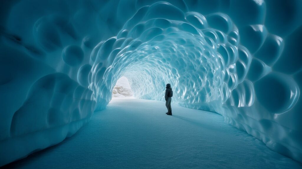
Map pin: Southeast Iceland. Ice caves feel unreal because light passes through layers of blue ice, making walls glow from within. Plan for depth: shoot with a wide lens from inside looking outward, then capture close-ups of bubble textures and ice striations. Include a person near an entrance for scale, but keep them small and still.
For photo planning, light changes quickly, so prioritize exposures that preserve highlights in bright openings while keeping wall detail. A slightly underexposed frame often holds the richest blues. Bring a strategy for moisture: lens fog can ruin sharp shots, so give your gear time to acclimate. Edit with restraint—blues can clip easily—so texture stays realistic instead of posterized. (Space)
9) Mono Lake, California
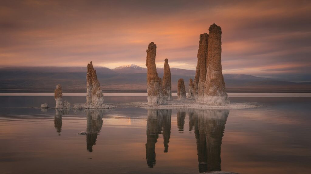
Map pin: Eastern California. Mono Lake’s tufa towers look like alien sculptures, especially when low water exposes tall formations. Plan for sunrise or sunset to get soft color and long shadows around the tufas. The best compositions use foreground tufa shapes as anchors, then layers of water and distant mountains to create depth.
For photo planning, shoot both wide and tight: wide frames show the strange shoreline, while tighter crops turn tufa into abstract forms. Calm water gives reflections; wind gives texture—both can work, so decide your visual goal before you arrive. A slightly warm edit can make the scene feel timeless, but keep it subtle so the rock still reads as mineral. (Space)
10) Wadi Rum, Jordan
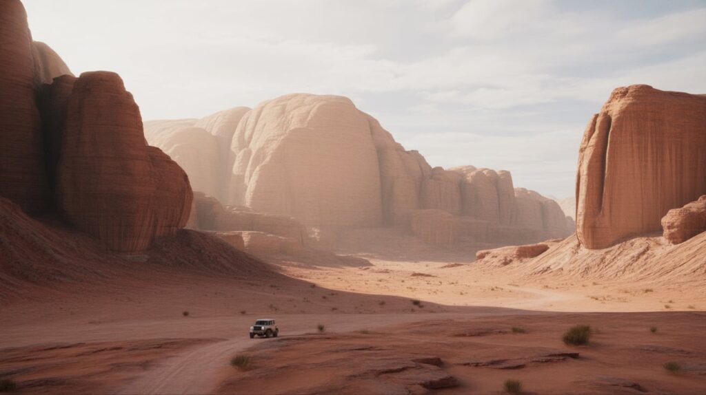
Map pin: Southern Jordan near the Saudi border. Wadi Rum looks unreal because the scale is enormous and the rock shapes feel sculpted. Photograph it with negative space: a small subject (jeep, camel, or person) placed against a massive wall of stone. Natural arches and narrow canyons also make strong “frame within frame” shots.
For photo planning, golden hour adds depth and warm gradients to the rock. Midday can still work if you focus on graphic shadows inside canyons. Keep your horizon straight, then let the landscape’s natural lines lead the eye. In post, preserve the desert’s reds without turning them orange; a gentle contrast curve often looks most natural. (UNESCO World Heritage Centre)
11) Nāhuku Lava Tube and Kīlauea Area, Hawaiʻi (USA)
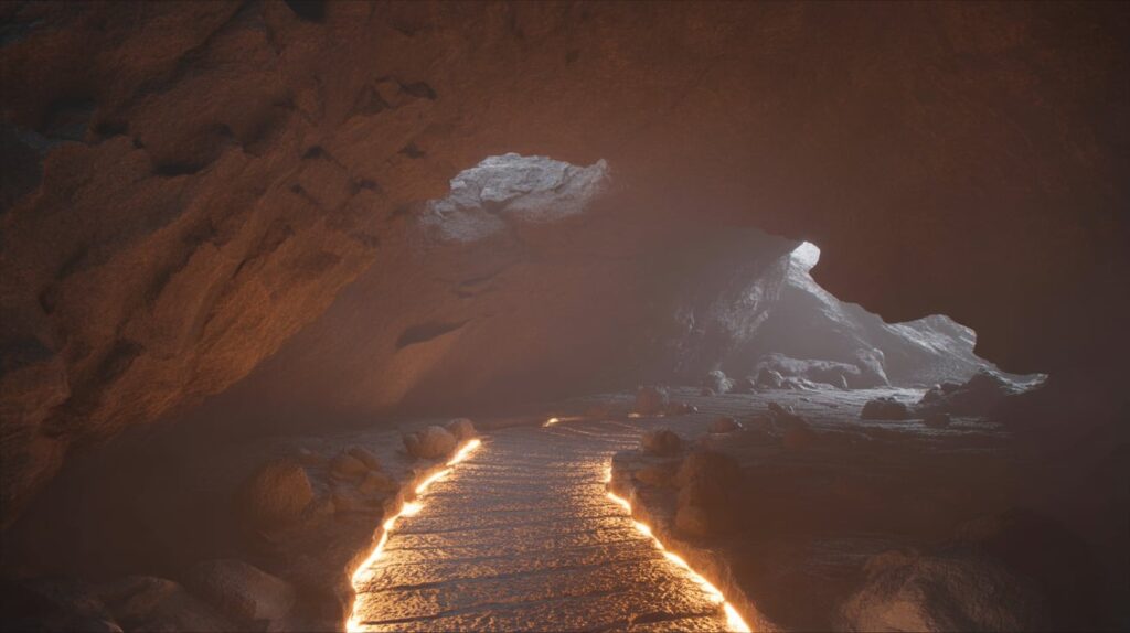
Map pin: Hawaiʻi Volcanoes National Park, Big Island. Lava tubes and volcanic fields look unreal because they feel like the inside of a planet. Plan a “dark-to-light” story: start inside the tube for texture and shadows, then step out to open lava landscapes. Use leading lines along paths or rock edges so viewers feel pulled into the scene.
For photo planning, stabilize your camera in low light and expose for highlights to keep detail in black rock. Wide lenses can exaggerate tunnel length, while a mid lens isolates wall textures. If you add a person, place them at a bend where the tunnel narrows, so the scale reads instantly. Edit with contrast and clarity, but keep blacks from crushing into flat darkness. (Space)
12) Deadvlei, Namibia (Sossusvlei Area)

Map pin: Namib-Naukluft National Park, Namibia. Deadvlei looks unreal because of its pure visual contrast: red dunes, white pan, black trees, and a clean sky. Plan for minimalism—center a single dead tree, then let dune curves fill the background. The strongest images use long shadows, so morning light is a major advantage.
For photo planning, carry a mid zoom to isolate trees against dune ridges, and a wide lens for the full surreal stage. Keep your horizon clean, and avoid cluttering the frame with too many trees unless you’re building a pattern. In editing, protect reds from over-saturation and keep whites neutral so the scene stays graphic instead of cartoonish. (Lonely Planet)
13) Waitomo Glowworm Caves, New Zealand
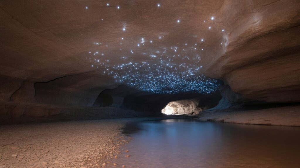
Map pin: Waikato Region, New Zealand. Glowworm caves look unreal because the ceiling becomes a living star map. Plan for mood: silhouettes, soft reflections, and minimal movement. The best visuals focus on contrast between darkness and the glow points, so compositions often work as simple horizontals with the “star” ceiling above.
For photo planning, expect controlled conditions and limited photography options depending on tour rules. If allowed, prioritize steady framing and low-noise settings that preserve glow detail. Avoid over-brightening in edits; the magic is in darkness with pinpoint lights. If your camera can’t capture it cleanly, plan a secondary shoot: entrance textures, river reflections, and cave openings. (Atlas Obscura)
14) Zhangye Danxia (Rainbow Mountains), China
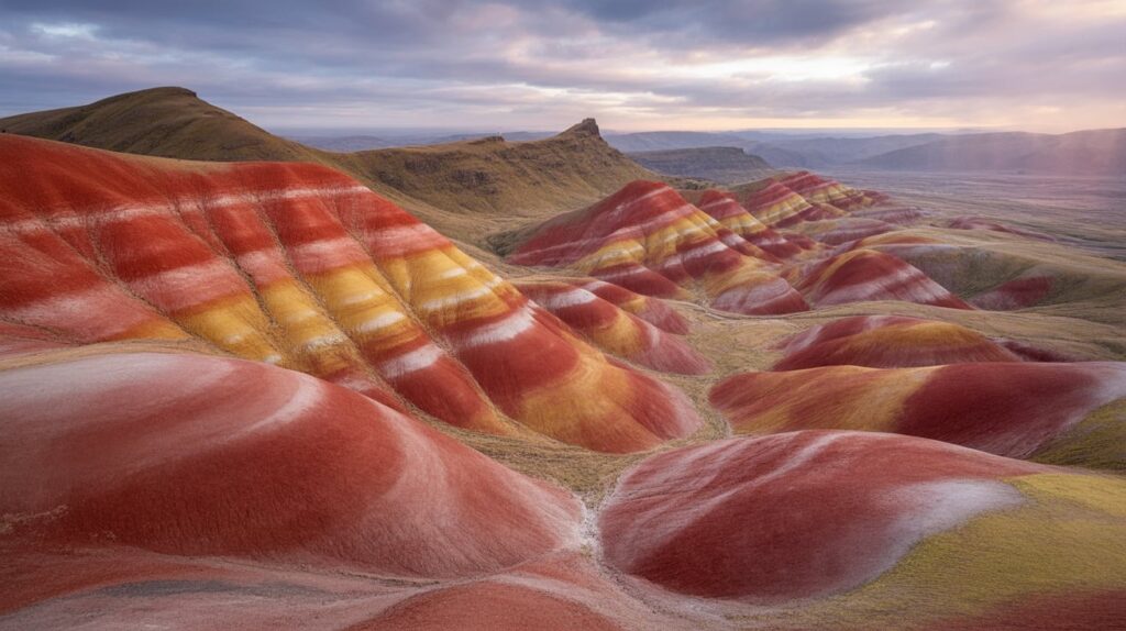
Map pin: Gansu Province, China. These mountains look painted, with layered bands that read like brush strokes across rolling hills. Plan for vantage points that show multiple ridges at once, because repetition sells the unreal look. Keep the frame clean: prioritize color layers and limit the sky if it’s hazy.
For photo planning, aim for side light that reveals ridge texture without flattening the stripes. Use a longer lens to compress layers and make the colors feel stacked. A light haze can even help, because it simplifies backgrounds and keeps attention on the stripes. In editing, increase micro-contrast more than saturation; texture often makes the colors feel real. (rte.ie)
15) Zhangjiajie National Forest Park, China
Map pin: Hunan Province, China. Zhangjiajie’s pillar peaks feel unreal because they rise like stone towers from a sea of forest and mist. Plan for layered depth: foreground trees, mid-ground pillars, background fog. Mist is not a problem here; it’s the entire mood. Wide shots create wonder, while telephoto frames turn peaks into floating forms.
For photo planning, watch weather patterns and shoot when clouds sit low among the pillars. Use a longer lens to stack peaks and intensify the “floating mountain” effect. Keep humans tiny or absent; scale comes from repeating towers. Edit for atmosphere: lift shadows slightly, protect highlights in fog, and keep greens natural rather than neon. (Wikipedia)
16) Cappadocia (Göreme), Turkey
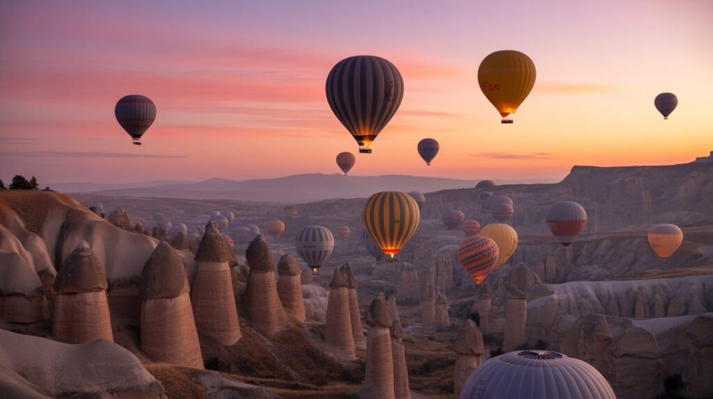
Map pin: Central Anatolia, Turkey. Cappadocia looks unreal because erosion shaped the valleys into towers and “fairy chimneys,” and balloons turn the sky into a moving pattern. Plan for two signature frames: a wide sunrise scene with many balloons, and a tighter shot where balloons float behind rock spires.
For photo planning, arrive before dawn to capture first light and the launch buildup. Use a longer lens to pack balloons together and simplify the valley. Keep your composition balanced: balloons high, rock forms low, and a clean horizon line. Edit with soft contrast so the scene stays airy, and avoid pushing oranges too hard. (UNESCO World Heritage Centre)
17) Pamukkale Travertines, Turkey
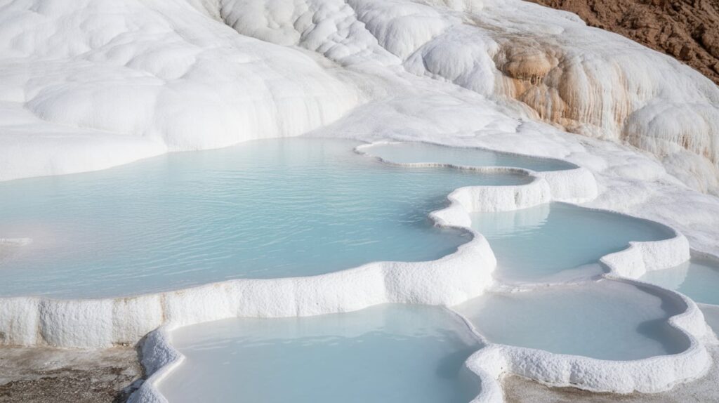
Map pin: Denizli Province, Turkey. Pamukkale feels unreal because the terraces look like frozen waterfalls made of bright white mineral deposits. Plan for bright, clean images: the terraces are the subject, so keep the frame uncluttered and let the water lines guide the eye. The most striking shots show repeating pools stepping into the distance.
For photo planning, choose light that reduces harsh shadows so whites stay smooth, not blown out. Expose for highlights first, then lift midtones carefully. Shoot details too—thin water edges and mineral textures make strong Pinterest close-ups. Keep color natural: pale blues and creamy whites look more believable than high-saturation edits. (UNESCO World Heritage Centre)
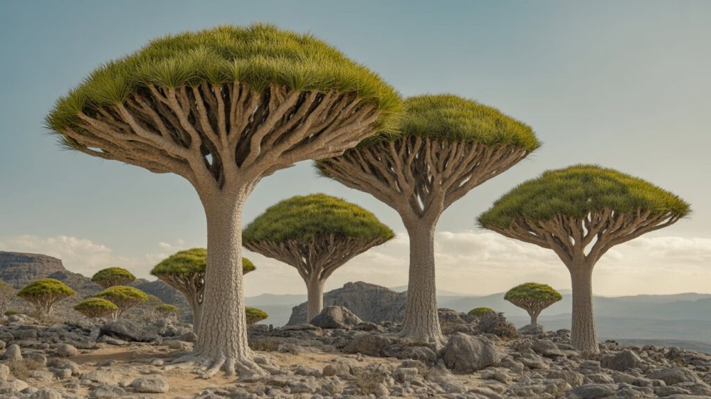
18) Socotra, Yemen
Map pin: Socotra Archipelago, Yemen. Socotra looks unreal because the plant shapes feel invented—especially the dragon blood trees with their umbrella silhouettes. Plan images like a botanical landscape: single trees as heroes, then wider shots that show clusters across rocky plateaus. The “other planet” effect improves when you keep the horizon simple and avoid modern elements.
For photo planning, prioritize soft light to give the trees depth and to separate branches from the sky. A mid lens helps isolate shapes cleanly; wide shots can make trees look smaller than they feel, so include scale carefully. Edit with gentle contrast and realistic greens, letting the tree form carry the strangeness rather than heavy filters. (Lonely Planet)
19) Great Blue Hole, Belize
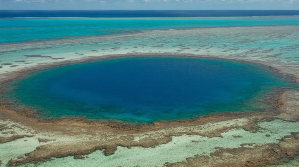
Map pin: Lighthouse Reef, Belize. The Great Blue Hole looks unreal because it’s a near-perfect dark circle cut into bright reef waters. The classic photo is aerial: center the circle, then let the reef’s lighter blues form a natural frame. If you can’t get aerial, plan a boat-level story: reef edge, open water, then divers entering.
For photo planning, emphasize geometry and color contrast. Keep the circle clean by avoiding extra horizon clutter and by using a slightly higher viewpoint if possible. In editing, protect the turquoise highlights so water stays luminous while the hole remains deep and dark. Add notes to your map pin about visibility and weather, because sea conditions affect clarity. (Live Science)
20) White Desert National Park, Egypt
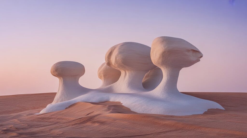
Map pin: Farafra Depression, Egypt. The White Desert looks unreal because wind and sand carved chalk into smooth, bright forms that resemble sculptures. Photograph it like an outdoor gallery: isolate one formation against empty desert, then widen out to show multiple shapes spaced across the landscape. Long shadows help define the chalk edges and make forms feel three-dimensional.
For photo planning, golden hour is ideal for sculpting texture while keeping whites from blowing out. Use a mid lens to avoid distortion on rock edges, then shoot one wide frame for context. Keep edits neutral: clean whites, warm light, and gentle contrast. Add a note to your map pin about nighttime potential—dark sky photos can be powerful here. (Wikipedia)
21) Mount Roraima (Canaima National Park), Venezuela
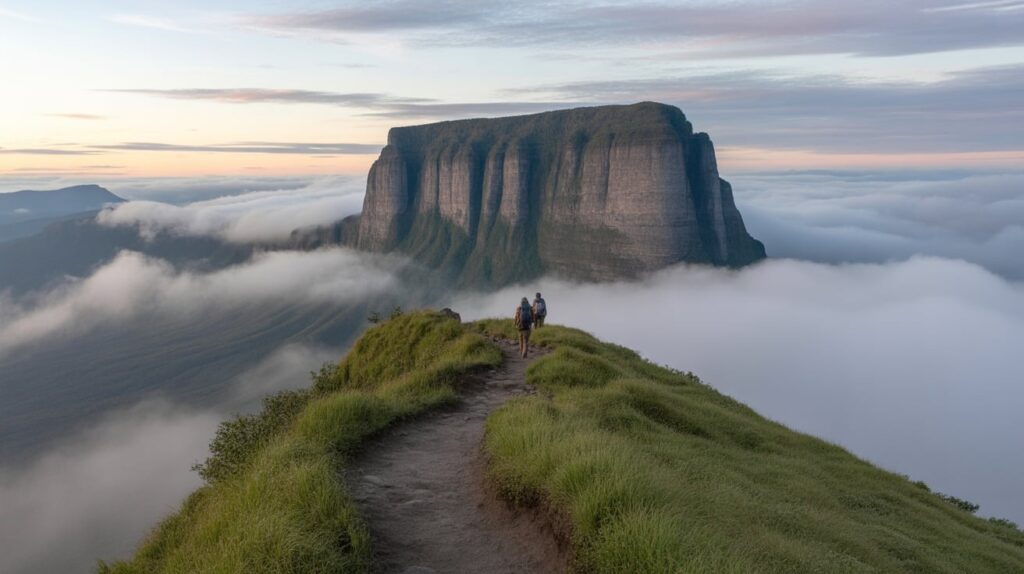
Map pin: Canaima National Park region, southeastern Venezuela. Tepui mountains look unreal because they’re massive table-top cliffs rising from rainforest, like a plateau dropped from the sky. Plan for mood: misty layers, cliff edges, and scale cues that show how steep the walls are. A wide frame with clouds wrapping the tepui often reads “impossible.”
For photo planning, prioritize vantage points that show the flat summit silhouette and the vertical cliff face in one frame. Use a telephoto option to compress clouds against the cliff for a floating effect. Edit for atmosphere: slightly lifted shadows and controlled highlights preserve the mist without losing rock texture. This pin works well with notes on trek timing and seasonal cloud patterns. (UNESCO World Heritage Centre)
22) Spotted Lake (kłlilx’w), British Columbia, Canada
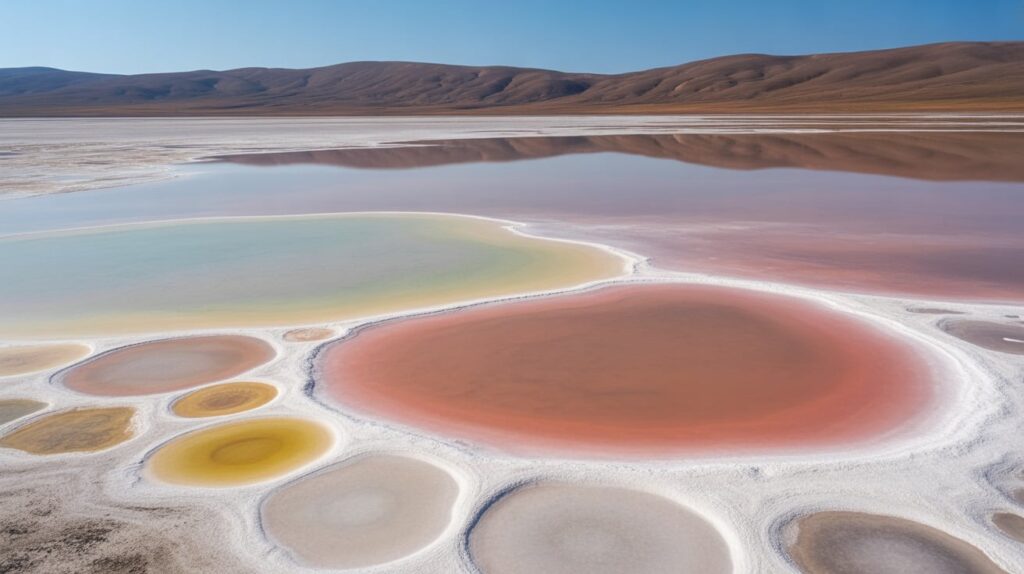
Map pin: Near Osoyoos, southern British Columbia. Spotted Lake looks unreal in hot months when evaporation reveals bright mineral circles like a giant doily. Plan to photograph from approved viewing areas and treat it as a pattern study. The strongest images minimize background and focus on the spots’ edges, colors, and spacing, turning the lake into abstract art.
For photo planning, midday light can work because it reduces shadow and makes circles read clearly. A longer lens helps crop distractions and compress the pattern into a tighter design. Keep edits natural, and let the mineral tones shift gently rather than forcing color. Make a note in your map pin that it’s a protected cultural site and deserves extra respect in how you approach and frame it. (Okanagan Nation Alliance)
23) Tsingy de Bemaraha, Madagascar
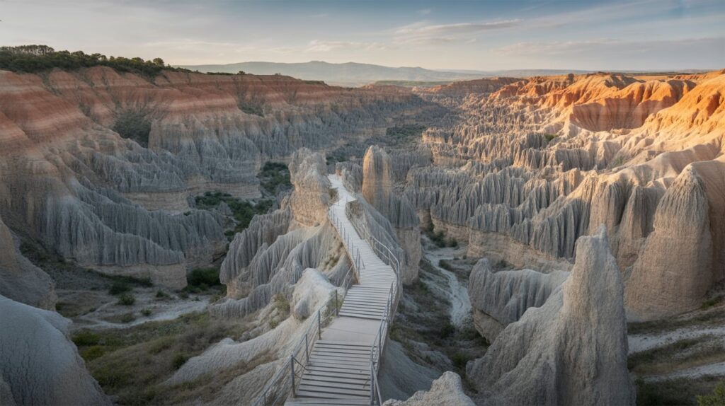
Map pin: Western Madagascar. Tsingy de Bemaraha looks unreal because limestone forms a jagged “stone forest” of needle-like peaks and deep canyons. Plan for depth: shoot along ridges so the pinnacles stack into the distance, then capture a human figure on a walkway to show scale. The landscape reads best when light comes from the side and casts hard shadows.
For photo planning, choose compositions that highlight the contrast between sharp rock and open voids. A wide lens can exaggerate the canyon drop, while a mid lens isolates repeating needles for graphic impact. Edit with crisp clarity and controlled contrast so the texture feels tactile without turning harsh.
Here’s your SEO‑ready article setup for 23 Places on Earth That Do Not Feel Real (Map for Photo Planning):
Conclusion:
From ethereal landscapes to vibrant natural wonders, these 23 surreal destinations remind us how extraordinary our planet truly is. Whether you’re planning a photo expedition or simply dreaming of your next adventure, adding these unreal‑feeling places to your list guarantees breathtaking imagery and unforgettable memories. Use the map to organize your route, pack your camera gear, and get ready to capture scenes that look almost too unreal to believe. Your next epic photo trip starts here!